July may have started with the warmest day yet recorded at this site, but the majority was very disappointing and nothing like summer. After that warm start, the month then reverted to a westerly Atlantic weather type which gave cool, dull and rather changeable weather. There was then only a few dry and warm days with the last ten days of the month particularly cool and dull. Through the month, whilst never heavy, rain or showers were frequent.
Temperatures were heavily suppressed, especially by day, with the mean maximum temperature significantly down on average by 1.5°c with only six days attaining 20°c, the last 20°c coming on the 16th after which they typically ranged from 15-17°c, but 13.1°c on the 28th was cold and a new lowest maximum temperature in July at this site.
MSLP of 1012.5 Mb was -2.0 Mb below the average for July due to the frequency of low pressure systems arriving from the Atlantic with high pressure only making rare and inconsequential forays.
Overall a mean minimum of 9.99°c and a mean maximum of 18.12°c saw the temperature 1.0°c below the 1981-2010 average, making it the coldest July since 2012. The highest maximum temperature recorded was 29.8°c (1st), the lowest minimum 5.4°c (26th).
Rainfall of 78.5 mm (Crosby Ravensworth School 87.0 mm) made it the wettest July since 2013 and here at Maulds Meaburn was 68.7% of average for 2007-14, but which is a false percentage and more demonstrative of just how wet recent July's have been. Compared to long term July rainfall, locally it was typically 135% of average.
At the Met' Office site at Newton Rigg, 87.8 mm (125.1 %) made it the wettest July since 2012 and in a series back to 1914 this makes it the 27th wettest in that time (3 years of missing data). A mean temperature of 13.85°c is the coldest since 2012 and sees July having been warmer in 44 years and colder in 14 occasions.
Figures from the Environment Agencyĺs rainfall sites were, (figure in brackets being the monthly average for 1961-90) ĹData kindly provided by the Hydrometry and Telemetry team of the Environment Agency (Penrith)ĺ:
Kirkby Thore 54.8 mm (39.8 mm)
Brothers Water 197.5 mm (142 mm)
Nunwick Hall 84.0 mm (65.8 mm) and
280.4 mm at Seathwaite Farm (Borrowdale - 204 mm [average for 1981-2010]).
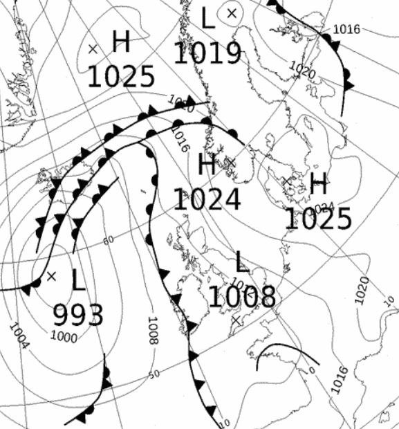
1st - 5th The month continued the pattern from the end of June, starting with high pressure over the continent drawing up a tropical continental airmass that brought hot and humid air from the south. This saw the 1st become the warmest day yet recorded at this site, 29.8°c (85.6°f), but with that humidity came variable amounts of cloud and which then set off the first thunder and lightning of the year, a 30 minute spell just before midnight.
We still had the humid flow from the south on the 2nd, but a cold front associated to low pressure (LP) west of Eire brought some rain in the afternoon. The 3rd was then a lovely day as HP (1027 MB) began to build over the UK and without the humidity it was a glorious 24.6°c and sunny.
But overnight into the 4th saw a warm front arrive that had pushed north out of France, heralding a return to humid conditions along with thunder and lightning. That thunder and lightning commenced at 0100 Hrs and lasted throughout the night and which gave several bursts of heavy rain, totalling 10.0 mm. HP again tried to build behind the warm front and a murky morning cleared to a sunny and breezy afternoon, with the HP lasting into the afternoon of the 5th before a little rain arrived.
6th - 8th It then became fresher with LP from the Atlantic moving across the UK and the 6-7th saw cloudy skies and a mix of showers and spells of light rain with the 6th having seen a drop in temperature to just 15.5°c.
As the LP tracked away north-east it dragged down a much cooler north-westerly flow on the 8th and the 9th then started on the cool side at just 5.8°c (42.4°f).
9th - 10th Two decent days then followed as HP built from the south west, with the LP of previous days now over Norway. Pleasant enough on the 9th, but the 10th saw 22.5°c before the HP gave way.
11th - 14th LP in the Atlantic tracking north-east to Faroe brought rain (6.9 mm) on its trailing frontal system during the evening of the 11th and overnight into the 12th. This was followed by another area of LP in the Atlantic on the 13th which had a long associated wave front which extended over the southern section of the UK. This gave a damp day and along with the 14th sunshine was at an absolute premium and temperatures fell back below 18°c.
15th - 16th High pressure then briefly returned and we had two decent days. The 15th was the sunnier day, but the 16th was warmer, reaching 22.3°c and the last day in July to reach 20°, but LP to the south-west was filling and moving north.
17th - 23rd Low pressure then became the dominant feature and the days became drab, cool and with limited sunshine, summer was on hold, but now entering the second half!
LP moved north through Eire overnight 16/17th and there was a little thunder in the early hours, but little rain. Some of the following days also became windy as HP over France pushed north, causing a 'squeeze' with the LP now sat north of Scotland and the 18th was notably fresh, only reaching a poor 15.9°c. There were spells of heavy rain in the early hours of the 19th, (credited back to the 18th) which gave 11.1 mm.
Another area of LP from the south west on the 20th would control the weather through to the 23rd. It slowly tracked north, positioning itself west of northern Scotland and then maintaining position until weakening on the 23rd. This saw the drab weather continue, sunshine remained at a premium and the odd light shower or spot of rain was the order of the somewhat cool days with the three days of 22nd-24th all between 15-16°.
24th - 25th Two slightly quieter days followed as the 24th saw a slack pressure gradient replace the LP with a ridge of HP on the 25th giving a fine day and some welcome sunshine. However, the temperature only reached 17.9°c which was actually the warmest day during the last eleven days of the month.
26th - 31st In fact the last ten days of the month only had a mean temperature of 11.96°c and after the 20th only one day was warmer than 16.5°c, with seven below 16°c - and the cool changeable weather continued.
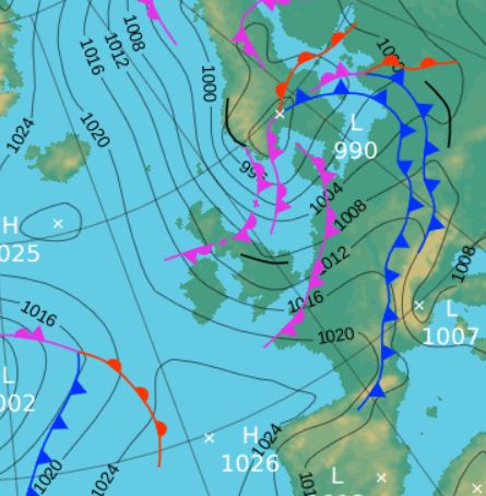
The ridge of HP gave way overnight into the 26th with rain arrived during the afternoon. That LP was slow moving and centred over northern England on the 27th which with 14.4 mm of rain was the month's wettest day.
The 28th remained dull and damp due to an occlusion trailing of the LP now centred over Denmark and now with a NNW'ly air flow it became decidedly cool and a maximum temperature of just 13.1°c (55.6°f) is the lowest July maximum yet recorded at this site.
There was a slight improvement 29-30th, which whilst remaining cool in the NNW'ly flow did see some sunny intervals as HP attempted to ridge in from the Atlantic. However, the 29th continued its run of being the only July day in my 7 years of records that is still to record 20°c.
The month then closed with LP in the Atlantic squeezing the HP south, giving a dull day with outbreaks of drizzle.
Rainfall totalled 78.5 mm for the month, with rain recorded on 23 days of which 16 were 'Wet days' (1.0mm +).
The Mean Temperature for the month was 14.05°c -- The Mean Max' was 18.12°c -- The Mean Min' 9.99°c.
We had 0 Air Frosts in the month (year 42) -- Grass frosts totalled 0 (year 92).
The 1 foot soil temp ranged from a low of 14.7°c on the 25th to a high of 16.9°c on the 2nd -- with a monthly mean of 15.9°c
The 1 meter soil temp ranged from a low of 12.5°c on the 1st to a high of 13.6°c on the 16-19th -- with a monthly mean of 13.3°c
COMPARISONS:-
* July 2015 rainfall was 68.7% of the July average for 2007 - 2014
* July 2015 was 0.97°c colder than the July average for 2009 - 2014 and 1.05°c colder than the local long term average 1981-2010
* 2014 Jan - July TEMP 9.48°c -- RAIN 800.1 mm
* 2013 Jan - July TEMP' 7.59°c -- RAIN 513.6 mm
* 2012 Jan - July TEMP' 8.16°c -- RAIN 601.3 mm
* 2011 Jan - July TEMP' 8.58°c -- RAIN 668.9 mm
* 2010 Jan - July TEMP' 7.50°c -- RAIN 314.2 mm
* 2009 Jan - July TEMP' 8.67°c -- RAIN 650.7 mm
* 2008 Jan - July TEMP' -- RAIN 723.7 mm
This makes the Jan' to July period of 2015 0.54°c colder than the average for 2009-14 and with 107.6% of average rainfall for 2008-14
JANUARY 2010
FEBRUARY 2010
MARCH 2010
APRIL 2010
MAY 2010
JUNE 2010
JULY 2010
AUGUST 2010
SEPTEMBER 2010
OCTOBER 2010
NOVEMBER 2010
DECEMBER 2010
JANUARY 2011
FEBRUARY 2011
MARCH 2011
APRIL 2011
MAY 2011
JUNE 2011
JULY 2011
AUGUST 2011
SEPTEMBER 2011
OCTOBER 2011
NOVEMBER 2011
DECEMBER 2011
JANUARY 2012
FEBRUARY 2012
MARCH 2012
APRIL 2012
MAY 2012
JUNE 2012
JULY 2012
AUGUST 2012
SEPTEMBER 2012
OCTOBER 2012
NOVEMBER 2012
DECEMBER 2012
SUMMER 2012
REVIEW OF 2012
JANUARY 2013
FEBRUARY 2013
MARCH 2013
APRIL 2013
MAY 2013
JUNE 2013
JULY 2013
AUGUST 2013
SEPTEMBER 2013
OCTOBER 2013
NOVEMBER 2013
DECEMBER 2013
REVIEW OF 2013
JANUARY 2014
FEBRUARY 2014
MARCH 2014
APRIL 2014
MAY 2014
JUNE 2014
JULY 2014
AUGUST 2014
SEPTEMBER 2014
OCTOBER 2014
NOVEMBER 2014
DECEMBER 2014
WINTER 2014
REVIEW OF 2014
JANUARY 2015
FEBRUARY 2015
MARCH 2015
APRIL 2015
MAY 2015
JUNE 2015
© Darren Rogers 2015
Want to comment on this site? email